

Do Precised Image Analysis Using Google Earth and Erdas Imagine
- Nov 10, 2017
- 1 min read
Nowadays GIS (Geographical Information System) and Remote Sensing are used in various field for Research, Projects, Planning and etc. Most of us use satellite imagery with resolution of 30m to 90m downloaded from various national and international organisations. Resolution of 30m or 90m doesn't allow to have precised look at land characteristics. Till now, I had done lot of Image Classification in satellite imagery. But it had lesser precision because of lower resolution, So How to maximize the level precision?
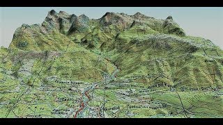
Above shown video clearly illustrated solution to maximize the precision level, for thsi happen open your erdas imagine and google earth connect both the tools. Now add your satellite imagery and if move or pan on erdas imagine, google earth also moves with the satelliete imagery . Thus you can zoom to identify the land features and past details of the particular location.
Comments